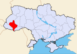
Ivano-Frankivsk Oblast
| Ivano-Frankivsk Oblast Івано-Франківська область Ivano-Frankivs’ka oblast’ |
|||
|---|---|---|---|
| — Oblast — | |||
|
|||
| Nickname(s): Івано-Франківщина (Ukrainian) Ivano-Frankivshchyna (transliteration) Prykarpattia |
|||
 |
|||
| Country | |||
| Established | December 4, 1939 | ||
| Admin. center | Ivano-Frankivsk | ||
| Largest cities | Ivano-Frankivsk, Kalush, Kolomyia | ||
| Government | |||
| - Governor | Mykhailo Vyshyvaniuk | ||
| - Oblast council | 120 seats | ||
| - Chairperson | Ihor Myroslavovych Oliinyk (RUKh) | ||
| Area | |||
| - Total | 13,900 km2 (5,366.8 sq mi) | ||
| - Land | ? km2 (Expression error: Unrecognised punctuation character "?" sq mi) | ||
| - Water | ? km2 (Expression error: Unrecognised punctuation character "?" sq mi) ?%% | ||
| Area rank | Ranked 22nd | ||
| Population (10/2008) | |||
| - Total | 1,381,700[1] | ||
| - Rank | Ranked 13th | ||
| - Density | Expression error: Unrecognised punctuation character ""/km2 (Expression error: Unexpected < operator/sq mi) | ||
| - Annual growth | -918 (01-10/2,008)% | ||
| Demographics | |||
| - Official language(s) | Ukrainian | ||
| - Average salary | UAH 889 (2006) | ||
| - Salary growth | ?% | ||
| Time zone | EET (UTC+2) | ||
| - Summer (DST) | EEST (UTC+3) | ||
| Postal code | 88-90xxx | ||
| Area code | +380-34 | ||
| ISO 3166 code | UA-26 | ||
| Raions | 14 | ||
| Cities of oblast subordinance | 5 | ||
| Cities (total) | 15 | ||
| Towns | 24 | ||
| Villages | 477[2][3] | ||
| FIPS 10-4 | UP06 | ||

Ivano-Frankivsk Oblast (Ukrainian: Івано-Франківська область, translit. Ivano-Frankivs’ka oblast’; also referred to as Ivano-Frankivshchyna) is an oblast (province) in western Ukraine. Its administrative center is Ivano-Frankivsk. The oblast was named after the Ukrainian writer and socialist Ivan Franko on November 9, 1962.
In the past the area was known as Stanisławów Voivodship (1918–1939) and Stanislav Oblast (1939–1962).
Contents |
Name
As with the rest of Ukraine's oblasts Ivano-Frankivsk may also be known by its matronymical name Ivano-Frankivshchyna. However, that name did not receive general public acceptance and commonly Ivano-Frankivsk Oblast is almost always called Prykarpattya – a historic name for the same region. (Geographically the historic region covers a much larger portion of Ukraine.)
Geography and Ethnography
Ivano-Frankivsk Oblast borders Lviv Oblast to its north and west, Zakarpattya Oblast to its south-west, has a 50-km long state border with Romania (Maramures County) to its immediate south, and it borders Chernivtsi Oblast to the south-east and Ternopil Oblast to the east. It is situated partly in the Eastern European Plain and partly at the foot of the Carpathian Mountains. The oblast may be divided into three regions: mountainous, pre-mountainous, and plains.
Relief
The Carpathian Mountains contribute tremendously to the change in relief of Ivano-Frankivsk Oblast and their elevation rises from north-east to south-west stretching along the oblast's south-western border. The elevation of the oblast varies from 230m to 2,061m above sea level. The mountains occupy almost one half of the whole Oblast and consist of two main mountain ranges: the Gorgany (highest peak - Mt. Syvulya Major (1,836m)) and the Chornohora range (highest peak - Mt. Goverla (2,061m)).
The rest of Ivano-Frankivsk Oblast is located within the Dniester river and Prut river valleys. The plains of the oblast are part of the Podolian (Podilian) Upland of the Eastern-European Plain and Upper Dniester Plain, which has a temperate-climate habitat mixed with grassland and woodland – also known as the forest steppe. The relief of the region consists mostly of rolling hills of 230-400m over the sea level.
The Dniester flows mainly through the Halych Raion and along the administrative border between Ivano-Frankivsk and Ternopil Oblasts. The region within immediate proximity to the river is traditionally known as Opillya. Opillya, however, stretches far beyond the oblast and only covers two of its raions: Halych Raion and Rohatyn Raion, both located in the north. Other major rivers include the Prut, the Cheremosh, the two Bystrytsia rivers, and others.
One third of the oblast is covered in woods. Prykarpattya possesses 10% of all Ukrainian forest resources.
The climate is mildly-continental and damp with cool summers and mild winters. The average monthly temperature in June is 18o C (~64.5o F) with 12-16o C (~53.5-61o F) in the mountains. The average monthly temperature in January is -4o C (~25o F) with -6o C (~22o F) in the mountains. The average precipitation varies annually around 650 mm (26) with 1550 mm (62) in the mountains.
Ethnography
The portion of the region along the mountains is traditionally occupied by Hutsuls, while the western portion is traditionally populated by Boykos – which includes such important cities as Kalush and Dolyna. From an ethnographical perspective it is interesting that most of the names of the Ukrainian Carpathians – such as Gorogany, Goverla, Grofa, Igrovets, Gropa, and many others – use the Ukrainian language sound "g" over the contemporary adopted language sound "h". The south-eastern portion of the oblast occupies the historical and ethnographic region of Pokuttya with its major city of Kolomyia.
Population
| Year | Population (in thousands) |
|---|---|
| 2001 |
|
| 10/2008 |
|
| 01/2009 |
|
| 01/2010 |
|
Nationalities
(as reported to the Ukrainian census of 2001)
| Language | Number | percentage (%) |
|---|---|---|
| Ukrainians | 1,371,242 | 97.50 |
| Russians | 24,925 | 1.80 |
| Others (Poles, Belorussians) | 4,532 | 0.32 |
| Total (seven nationalities) | 1,406,129 | 100.00 |
Historical and Cultural Sites
- Recently, a monument of cultural heritage was erected in the city of Kolomyya in Pokuttya. The museum "Pysanka" was built in 2000 and is the only one in the world.
- Another interesting historical site is the cavern complex in the Dovbush Rock. The site is dedicated to the legendary freedom fighter Oleksa Dovbush who in the legend fights against the Polish szlachta. The rock complex is located about 7 miles south west from Bolekhiv near village of Bubnysche.
- The Church of the Holy Spirit, built in 1598, is located in the north of the Oblast in the small city of Rohatyn.
Oblast council
Regional representation in the Oblast council by raions and cities with special status during the first three convocations (1990 – 2002):
| Raion | Council seats in 1990 |
Council seats in 1994 |
Council seats in 1998 |
|---|---|---|---|
| Bohorodchany Raion |
|
|
|
| Verkhovyna Raion |
|
|
|
| Halych Raion |
|
|
|
| Horodenka Raion |
|
|
|
| Dolyna Raion |
|
|
|
| Kalush Raion |
|
|
|
| Kolomyia Raion |
|
|
|
| Kosiv Raion |
|
|
|
| Nadvirna Raion |
|
|
|
| Rohatyn Raion |
|
|
|
| Rozhniativ Raion |
|
|
|
| Sniatyn Raion |
|
|
|
| Tysmenytsia Raion |
|
|
|
| Tlumach Raion |
|
|
|
| Ivano-Frankivsk City |
|
|
|
| Bolekhiv City |
|
|
|
| Kalush City |
|
|
|
| Kolomyia City |
|
|
|
| Yaremche City |
|
|
|
| Total |
|
|
|
In 2006, the V convocation of the Oblast Council:
- Chairman: Ivan Oliynyk (Our Ukraine Bloc)
In 2002, the IV convocation of the Oblast Council:
- Chairman: Vasyl Brus (unaffiliated)
Chairmen of council
- 03/2006 - present Ihor Oliynyk Our Ukraine Bloc (Rukh)
- 2002 - 03/2006 Vasyl Brus unaffiliated (Ivano-Frankivsk representative)
- 1998 - 2002 Zinovi Mytnyk (Kolomyia representative)
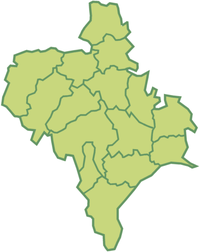
Subdivisions
The Ivano-Frankivsk Oblast is administratively subdivided into 14 raions (districts) as well as 5 cities (municipalities) which represent a separate raion and are directly subordinate to the oblast government: Bolekhiv, Kalush, Kolomyya, Yaremche, and the administrative center of the oblast, Ivano-Frankivsk.
The oblast has 15 cities which are (alphabetical order): Bolekhiv, Burshtyn, Dolyna, Halych, Horodenka, Ivano-Frankivsk, Kalush, Kolomyia, Kosiv, Nadvirna, Rohatyn, Sniatyn, Tlumach, Tysmenytsia, and Yaremche. Five of those cities are of oblast importance and the other ten are of raion importance. The oblast also has 24 towns or urbanized settlements. The other settlements are rural and accounted for some 765 localities including villages and 20 selyshches (smaller villages) which are administered by 477 village councils. Note the difference between cities of oblast and raion importance – one category subordinates directly to the oblast and the other does not. The cities of oblast importance are analogous to municipalities and have a separate representation in the oblast council; unlike the rest of the cities which are represented collectively by the raion where they are located within. That issue was particularly acute in the 1990s and led to some reformation within the oblast council (see Oblast council section).
The division into raions somewhat resembles the former Polish powiats of the Stanislawow voivodeship. Three powiats that were located west and north-west were transferred to the Drohobych Oblast: Skole, Stryi, and Zhydachow. Several powiats were simply reformed into raions, although a lot changes took place since then. In the Soviet period the oblast had such raions as Bolekhiv, Bilshivtsi, Burshtyn, and others, which later were incorporated into other raions. In 1964 the Bolekhiv Raion was merged with Dolyna Raion. Please consider that the following map shows the Yaremche Raion. The city of Yaremche has rather a municipal administration with a special status and does cover a substantial area, however the same situation is with the city of Bolekhiv which on the following map is not identified.
 |
|||
| In English | In Ukrainian | Administrative Center | |
|---|---|---|---|
| Bohorodchany Raion January 20, 1940 |
Богородчанський район Bohorodchans'kyi raion |
Bohorodchany (Urban-type settlement) |
|
| Dolyna Raion January 20, 1940 |
Долинський район Dolyns'kyi raion |
Dolyna (City) |
|
| Halych Raion January 20, 1940 |
Галицький район Halyts'kyi raion |
Halych (City) |
|
| Horodenka Raion January 20, 1940 |
Городенківський район Horodenkivs'kyi raion |
Horodenka (City) |
|
| Kalush Raion January 20, 1940 |
Калуський район Kalus'kyi raion |
Kalush (City) |
|
| Kolomyia Raion January 20, 1940 |
Коломийський район Kolomyis'kyi raion |
Kolomyia (City) |
|
| Kosiv Raion January 20, 1940 |
Косівський район Kosivs'kyi raion |
Kosiv (City) |
|
| Nadvirna Raion January 20, 1940 |
Надвірнянський район ? raion |
Nadvirna (City) |
|
| Rohatyn Raion January 20, 1940 |
Рогатинський район Rohatyns'kyi raion |
Rohatyn (City) |
|
| Rozhniativ Raion January 20, 1940 |
Рожнятівський район Rozhniativs'kyi raion |
Rozhniativ (Urban-type settlement) |
|
| Sniatyn Raion January 20, 1940 |
Снятинський район Sniatyns'kyi raion |
Sniatyn (City) |
|
| Tlumach Raion January 20, 1940 |
Тлумацький район Tlumats'kyi raion |
Tlumach (City) |
|
| Tysmenytsia Raion January 20, 1940 |
Тисменицький район Tysmenyts'kyi raion |
Tysmenytsia (City) |
|
| Verkhovyna Raion | Верховинський район Verkhovyns'kyi raion |
Verkhovyna (Urban-type settlement) |
|
Largest Cities
(Cities of over 10,000 residents)
| City | Population |
|---|---|
| Ivano-Frankivsk | 215,288[4] |
| Kalush | 67,887[5] |
| Kolomyia | 61,448[6] |
| Dolyna | 20,696[7] |
| Nadvirna | 20,620[8] |
| Burshtyn | 15,182[9] |
| Perehinske | 12,272[10] |
| Bolekhiv | 10,590[11] |
| Sniatyn | 10,210[12] |
Culture and Tourism
Ivano Frankivsk Oblast is home of numerous cultural festivals. There are numerous natural and architectural benchmarks that are scattered throughout the region.
One of the famous festivals is the Ukrainian International festival of ethnic music and land art "Sheshory" that usually takes place in the picturesque Hutsul village of the Kosiv Raion Sheshory since 2003.[13] From 2007, however the festival has spread throughout the country taking place in Podillya, Kiev Oblast, and other places. In August 2010 the village of Spas in the Kolomyia Raion hosted a culinary event Smachny Spas in association with "Sheshory", while in July of the same year another eco-cultural event Trypilske kolo in the Rzhyschiv city of Kiev Oblast.
The city of Ivano-Frankivsk hosts several other festivals such as the All-Ukrainian festival of art collectives "Carpathian Spring" that takes place every May. Every two year the festival of modern art "Impreza" takes place every other year. Every odd year the city hosts the festival national-patriotic music and poetry "Freedom". Since May 2001 every year the city of Ivano-Frankivsk is the capital of the European blacksmith movement hosting the "Festival of blacksmith" and the art exhibition "Ornamental Forging" that takes place at the Mickewicz Square and neighboring Andrei Sheptytsky Square in city's old town.
On the territory of Ivano-Frankivsk Oblast are located numerous monuments of architectural heritage. On February 8, 1994 near the city of Halych was established the National preserve "Ancient Halych".[14] Among other important sites in the region is the Church of the Holy Spirit located in the city of Rohatyn as well as the Skyt Manyavsky (monastery) near the village of Manyava in Bohorodchany Raion. The oblast also accounts for some number of various wooden churches of Boykos and Hutsuls traditional architecture.
In the Dolyna Raion (western region) visitors can find the Carpathian Train that still uses the narrow gauge railway system. Train is used for its direct purpose transporting wood as well as for a tourist recreation. The biggest benchmark of the region is the Hoverla mountain, the tallest in the nation. However due to increased touristic activities in the post-Soviet times the mountain is a subject to a high degree of pollution. No less interesting destination serve the Dovbush rocks that are located near the city of Bolekhiv in mountains. That location was a base of an anti-Polish Peasant movement. Near the Skyt Manyavsky is located the highest waterfall in Ukraine, the Manyava waterfall (22m). In the same Bohorodchany Raion visitors may find the local mud volcano located near the village of Starunia. It was noticed for the first time in 1977 after an earthquake that took place in Romania.
See also
- Poland’s Stanisławów Voivodeship (1921–1939)
- List of Canadian place names of Ukrainian origin – Ukrainian immigrants to Canada brought place names from this oblast to Saskatchewan; a few one-room schools had names of villages from this region.
- Ivano-Frankivsk Oblast local election, 2006
- List of heads of government in Ivano-Frankivsk Oblast and Stanislawow Voivodeship
References
- Notes
- ↑ Statistics (Ukrainian)
- ↑ That includes rural councils which may have several villages or rural settlements (selyshcha).
- ↑ Subdivision listings (Ukrainian)
- ↑ Verkhovna Rada Official web-site
- ↑ Verkhovna Rada Official web-site
- ↑ Verkhovna Rada Official web-site
- ↑ Verkhovna Rada Official web-site
- ↑ Verkhovna Rada Official web-site
- ↑ Verkhovna Rada Official web-site
- ↑ Verkhovna Rada Official web-site
- ↑ Verkhovna Rada Official web-site
- ↑ Verkhovna Rada Official web-site
- ↑ Shehsory festival (Ukrainian)
- ↑ Офіційний сайт заповідника Ancient Halych
External links
- Ivano-Frankivsk Oblast official site
- Oblast council official site (Ukrainian)
- "JewishGalicia.net" – Jewish history in the Ivano-Frankivsk Oblast
- Handbook on history of Communist Party and Soviet Union
|
|||||||
|
|||||||||||||||||||

|
|||||||||||||||||